A) Weather Forecast Offices.
B) National Cyclone Center.
C) State Weather Forecast Offices.
D) National Centers for Environmental Prediction.
F) B) and D)
Correct Answer

verified
Correct Answer
verified
Short Answer
What type of image allows meteorologists to distinguish between thick cold clouds and thin warm clouds?
Correct Answer

verified
Correct Answer
verified
True/False
Synoptic weather forecasting was developed before numerical weather prediction.
B) False
Correct Answer

verified
Correct Answer
verified
Multiple Choice
One of the primary uses for a 500-mb map is:
A) to estimate surface air temperature.
B) to predict surface wind speeds.
C) to determine the speed and direction of motion for a mid-latitude cyclone.
D) to monitor the position of the polar jet stream.
F) B) and C)
Correct Answer

verified
Correct Answer
verified
Multiple Choice
In numerical weather prediction,what is the hydrostatic equation used to describe?
A) changes in atmospheric density
B) vertical motion in the atmosphere
C) the impacts of changing temperature
D) horizontal advection
F) None of the above
Correct Answer

verified
Correct Answer
verified
Multiple Choice
The Storm Prediction Center in Norman,Oklahoma,maintains a constant vigil for:
A) snow storms.
B) hurricanes and tropical storms.
C) floods and flash floods.
D) thunderstorms and tornadoes.
F) A) and D)
Correct Answer

verified
Correct Answer
verified
Short Answer
In this process a search is made for analogous past weather records: ________.
Correct Answer

verified
analog met...View Answer
Show Answer
Correct Answer
verified
View Answer
Multiple Choice
The job of collecting,compiling and displaying weather data is done by:
A) a weather prognostic.
B) a weather forecaster.
C) a weather reporter.
D) a weather analyst.
F) B) and D)
Correct Answer

verified
Correct Answer
verified
True/False
Infrared imagery,like visible imagery,can only detect the presence of clouds during the day.
B) False
Correct Answer

verified
Correct Answer
verified
Multiple Choice
Weather analysis includes all of the following EXCEPT:
A) plotting numerical data.
B) collecting data.
C) compiling data.
D) transmitting data.
E) prediction of future weather data.
G) D) and E)
Correct Answer

verified
Correct Answer
verified
True/False
Only 50 nations are involved in the World Meteorological Organization.
B) False
Correct Answer

verified
Correct Answer
verified
Multiple Choice
On a surface-level synoptic weather chart,a front is often identified by zones that exhibit:
A) a strong jet stream.
B) clear skies.
C) gradual changes in pressure.
D) abrupt changes in temperature,humidity,and wind direction.
F) A) and B)
Correct Answer

verified
Correct Answer
verified
Multiple Choice
Which of the following weather data is not always plotted in the same location with respect to the weather station?
A) cloud type
B) past weather
C) barometric pressure
D) pressure tendency
E) wind direction
G) A) and B)
Correct Answer

verified
Correct Answer
verified
Multiple Choice
Airflow aloft is often illustrated with ________,lines of equal wind speed.
A) isotachs
B) isobars
C) isovels
D) isometers
F) A) and C)
Correct Answer

verified
Correct Answer
verified
Multiple Choice
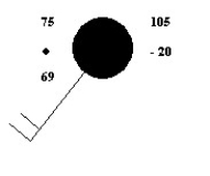
 -What is the current air temperature represented on the station model shown above?
A) 75°F
B) 75°C
C) 69°F
D) -20°C
E) 105°F
G) B) and C)
Correct Answer

verified
Correct Answer
verified
Multiple Choice
 -What is the dew point represented on the station model shown above?
A) -20°C
B) 75°F
C) 69°F
D) 69°C
F) A) and D)
Correct Answer

verified
Correct Answer
verified
Multiple Choice
The path that cyclonic storms follow (storm track) is usually farther to the south during:
A) nighttime.
B) autumn.
C) summer.
D) winter.
F) A) and B)
Correct Answer

verified
Correct Answer
verified
True/False
Infrared images are obtained from radiation emitted from objects.
B) False
Correct Answer

verified
Correct Answer
verified
Multiple Choice
________ assume(s) that the weather occurring upstream will persist and move on to affect the area in its path.
A) Trend forecasting
B) Nowcasting
C) The analog method
D) Persistence forecasts
F) All of the above
Correct Answer

verified
Correct Answer
verified
Multiple Choice
Why is the pattern of upper-level winds an important part of the forecasting process?
A) Rainfall at the surface corresponds to westerly flow aloft.
B) It strongly influences the development of surface storms.
C) Surface pressure controls the wind aloft.
D) Jet streams aloft always lead to storms.
F) A) and D)
Correct Answer

verified
Correct Answer
verified
Showing 61 - 80 of 95
Related Exams